Products
SIG CTM
Territorial Information System of the Multi-purpose Technical Registry
Read More
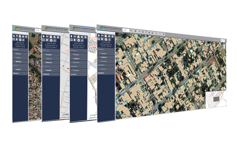
It is an important tool in the management of information produced and used in public administration. Due to its multi-purpose nature, it caters to all managerial areas of the municipalities through 11 business modules composed of features aimed at queries and maintenance of the agencies’ corporate database.
The SIT CTM can be integrated with the Municipal Tax System. This allows the exchange of information between both systems and, thus, enhances the capacity of analysis and control of property and taxpayers’ registration information. With that, it can identify defaults, properties current with the IPTU tax, among other information and analyses. A major advantage of the SIT CTM is its specific feature for managing data related to the Generic Value Plan, IPTU, ISS and municipal ITBI taxes.
It performs geographic edits to business elements and more specific data analyses. The maintenance of geographic layers attributes, general data analyses, report queries, and thematic map printings are performed directly on the web system through the business modules.
Data and features are subject to rules of profile access based on login and password. In addition to the access of municipal servants and technicians, the SIT CTM allows citizens to access certain information and features, so that the population can access maps and basic information of the municipality. This functionality improves and automates services to citizens, streamlining the issuance of licenses and the municipal tax collection.
The SIT CTM offers two solutions: one employing free and licensed computer systems, and one employing only licensed systems. Both have been widely used and validated by important Brazilian municipalities.
It is worth mentioning that EGL Engineering has qualified technical team to adjust the SIT CTM according to the specific needs of the client, integrating it with other municipal systems, as well as performing registration data and aerial imaging survey that may be part of the SIT georeferenced database.
CCO and CSO
Passengers Transportation Management and Operational Control System
Read More
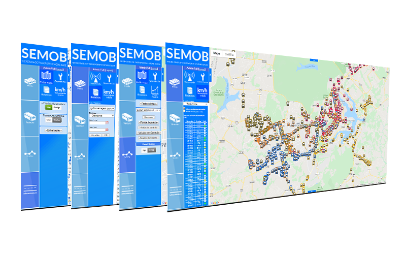
The System, designed to be functional and low-cost, allows the operator to monitor the entire business chain and act in real time on any activity related to the services provided by the company, from the time the bus leaves garage until the moment it returns.
CCO and CSO are fully online, operating 24 hours a day, 365 days a year, storing all information clients want to control. This way, barriers are broken down and the operator can make decisions anywhere in the world.
The system is modular and can be implemented in phases and customized to the specific needs of each client. Through this flexibility, EGL Engineering is committed to deliver the solution that best fits into the client’s characteristics, providing all the requested information in the desired format.
EGL Engineering’s CCO & CSO is accredited to the supplier chain of the BNDES Card Operations Portal. The BNDES Card is a product that, based on the credit card concept, aims to finance investments by private companies, public companies and autonomous entities. Access here and purchase the Passengers Transportation Management and Operational Control System for your company.
In 2013, with the new concession agreement for public transportation services of the Federal District, the DFTrans managerial agency implemented the EGL Engineering’s CSO solution as a transition platform.
The model was elected for its flexibility and interoperability, being able to meet the needs of the agency and operate with any type of transmission hardware.
The start of this operation was on the G1 News Portal in October and November 2013.
Watch the news and learn a little more about EGL Engineering’s CSO!
SICG IPHAN
Integrated System of Knowledge and Management designed to IPHAN
Read More
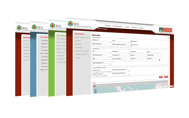
The system became a reference in the federal government due to its development in record time using agile methodology. One of its articles has even been published on the geo world website “Geotecnologias Livres no Setor Publico”. It consists of three modules: knowledge, management and registry. Modules present fields of data, intelligence and structured relationships to capture and organize information according to the IPHAN objectives such as identification, recognition, monitoring, inspection or licensing of heritage.
Currently, the SICG enables registering, in one single operation, the historical and cultural heritage assets providing their actual geographic location and address. Thus, assets can be associated with the historical and geographic context to which they belong. This way, the Institute can more easily manage its assets, just needing a GPS to find them and make the necessary inspections.
Another great innovation of the system is that population can access information related to the historical and cultural heritage of Brazil. The application developed allows access to citizens through the available web-based services, greatly benefiting the Brazilian culture.
System modules
The SICG consists of a dataset pooled in three modules: knowledge, management and registry. Each module corresponds to a sphere of approach to historical and cultural heritage, and has a set of data, intelligence and structured relationships fields to gather and organize information according to the purpose of the process involved, be it identification, recognition, monitoring, supervision or licensing. The modules were designed to allow a broad approach of heritage. It ranges from general to specific, with thematic and territorial focuses. The modules allow, for example, the use of other methodologies, such as the National Inventory of Cultural References – INRC.
GEOSISLIC
Georeferenced System of Permissions and Inspection Acts of Civil Works and Postures
Read More
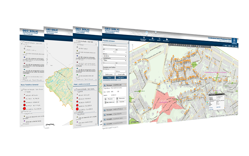
In addition to georeferencing all data of permissions and inspections acts existing in the previous system in a non-referenced way, the new system allows queries, crossing and spatial analyses on the attributes and geographic layers from different data sources, including BI tools and OLAP analyses. The results of data crossing are viewed on maps, reports and graphs in a quick way compliant to the users’ attributions.
Following are the system modules: Operational, Analysis, Administration, Legacy Treatment and Managerial Information (including the Business Intelligence tools and OLAP Cubes generation).
Operational Module: allows georeferencing a given event (processes and products) being analyzed by the licensor. It offers a set of tools that allow georeferencing products and administrative acts in a direct and most automated way as possible, demanding minimum effort from users.
Analysis module: enables queries and analysis of literal (alphanumeric) and geographic (maps) data. It allows complex analyses resulting from one-time and extraordinary demands, as it allows exporting data from the Analytical Database to perform other external analyses based on information the user extracted from the GeoSISLIC and that will be analyzed on Excel and ArcGis supporting tools.
Administration Module: responsible for managing users, administering accesses and permissions to access the modules and features available. It allows setting up other aspects of the system such as incorporation of new map services, printing services or overall password expiration date.
Legacy Treatment Module: aims at the treatment and georeferencing of the pre-existing municipal database.
Managerial information: it is composed of reports, thematic maps, cartogram and pre-defined general and managerial graphs. This module includes the Business Intelligence (BI) tool that comprises accounting operations, both summarized and pooled, and allows free crossing of all pre-defined data, also enabling temporal analyses and historical series.
Contact Us
Contact us for a free diagnosis and recommendations on preliminary actions.
Address
Complex The Union
SMAS Trecho 3 Conj. 3 Bloco A Sala 215 Brasília-DF
CEP: 70.610-635
It is located in a business complex, which allows holding small, medium and big events.
Phones
+55 (61) 3032-6303 | (61) 3248-1811
---EGL")